DeedMapper Deed Entry Form

How to force the DeedMapper software program to display the Deed Entry Form every time a new deed is entered.

I received and installed the DeedMapper 4.2 upgrade about two weeks ago and immediately wanted to get started platting some of the 19th century New Jersey deeds that I have transcribed this year. Problem is, when I launched the program, I did not know where to start. I expected the Deed Entry Form to open when I opened a new deed, but it did not. All I saw was a vast empty screen:

deedmapper-main-windowThe DeedMapper Plot View screen

Here is how to activate the Deed Entry Form:

deedmapper-edit-deed-button

In the Plot View window, click the Edit Deed button shown above, just to the left of the Annotate button (the one that looks like a T). The Edit Deed button also appears on the Table View window.

deedmapper deed entry form
The DeedMapper Deed Entry Form simplifies deed data entry but is not enabled by default.

The Deed Entry Form was one of the enhancements in version 4 of the software that simplifies data entry but is not enabled by default. To force the program to open the Deed Entry Form every time a new deed file is started go to View > Options  and select the Text View tab. Under New deed entry on the left, click the radio button to select Deed entry form. The next time you open the program the Deed Entry Form will display automatically.

deedmapper view options window

I have used my new DeedMapper software upgrade to successfully plat three metes and bounds style surveys of land that I believe are relevant to my early Carson family research in Mercer County, New Jersey. The next order of business is to actually place these plat drawings on a contemporary New Jersey map. I have consulted a gazetteer to hone in on what hamlet or township various features described in deeds were located in to track down the proper maps.

deedmapper data entry form with first call
The land described in this 1842 deed from Abraham Rogers and wife to Aaron Eldredge was acquired by Daniel Carson just a few years later. The data entry form above shows the first call in the survey.

Carefully reading, transcribing and platting deeds surveyed using metes and bounds methods will reveal relationships and neighbors, and is a useful exercise in your genealogy research.

Establishing a Death Date for Charles Carson

Carson Family Group Sheet (Pt. 4)

Fourth in an ongoing series that attempts to document the early days of my research on the Carson family of New Jersey as it originally unfolded. In this installment describing research conducted in 2002-2003, I established a tentative death date for my ancestor, Charles Carson.

I suspected that my 3rd-great-grandfather Charles Carson of Mercer County, New Jersey died at a relatively young age.

From prior research in the Federal census population schedules (highlighted in this post) I learned that he was 26 years of age in 1850, and age 36 in 1860. I estimated his year of birth as circa 1824 from those two records. The 1860 census was the last record in which he was found.

He was not among immediate family members by the time of the 1870 census. By 1881, his wife, Caroline Carson, was called a widow. Using all of this information, I can bracket his possible date of death as sometime after 1 June 1860 and before early 1881, a 20-21 year range. Thus, he would have been no younger than 35 and no older than 57 years of age when he died, depending on how early in the year he was born.

Can I narrow down that window of time?

Any American male aged 18-60 that disappears from a family in the first half of the decade of the 1860’s is a candidate for Civil War service. Charles was definitely in that age range.

Civil War service as a volunteer can be quickly verified by a look-up on the Civil War Soldiers and Sailors System (CWSS) website maintained by the National Park Service. With over 6.3 million names of soldiers indexed, representing participants from both Union and Confederate forces, it is one of my first stops when beginning new research on a potential soldier in the American Civil War (1861-1865). Names in this database were entered as found on the Compiled Service Records, created in the latter portion of the 19th century.

soldiers-and-sailors-database

I clicked on Soldiers and entered basic search criteria:
First Name: Charles
Last Name: Carson
Side: Union

cwss-search-charles-carson-civil-war-service
Search box detail. Click to enlarge this or any other photo.

Forty-seven soldiers named Charles Carson were included in my search results (including Colored Troops and Home Guards), but none saw service in a New Jersey regiment. I doubted with at least six children at home that he would have traveled to another state to join up.

I also ran a search for Charles Carson in the 1876 publication “Record of Officers and Men from New Jersey in the Civil War, 1861-1865″….by Adjutant-General William S. Stryker and found no listing for any officer or soldier named Charles Carson. This volume is available in digital form from the New Jersey State Library at this link.

If Carson died between 1861 and 1865, it was unlikely the result of any wartime service unless, perhaps, he was a career soldier, as compiled military service records were not created for “Regulars”. Since I had no information that directly suggested service in the Civil War in any capacity, I decided to table this research angle. Even though this search yielded negative results, it was necessary to document that I did consider military service as a possibility.

What other information could I uncover that might suggest a death date for Charles Carson?

It was November 2002 when I turned to GenForum, my genealogy message board of choice (which has recently transitioned to a read-only archive of former queries and posts). There on the Kansas board I found a query posted mere weeks prior that mentioned both Furman Carson and his father, Charles Carson.1 I saw other names that I knew from my own research among the list of children, so posted a response.2 It was not long before I received a notification that a reader had responded to my query. We compared notes and in short order determined that our 2nd-great-grandfathers were brothers. Some of our family information meshed quite well, but some of it differed. For example, she identified our known common ancestor as Charles C. Carson, and showed his death in 1896, and not “before 1881” as my research indicated. My cousin also had information on the purported maiden surname of his wife Caroline.

How to resolve this conflicting information? With more research, of course! As I would learn, much of this information was provided to her by a third party, without source citations. I began to attempt to verify my new cousin’s alleged facts, but also continued to look for records that would support my hypothesis. I found it difficult to believe that Caroline’s husband Charles simply dropped off the grid between 1860 and 1896. I was aware of other males named Charles Carson living in the greater Trenton area in the mid to late 19th century, so figured the 1896 death date attributed to my Charles really was that of another man. But, I would have to prove this before dismissing it completely.

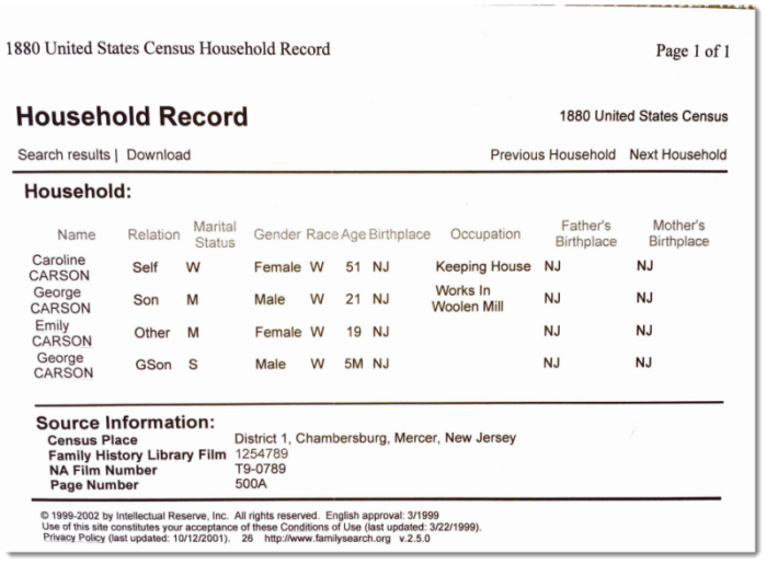
I next searched the 1880 U.S. census index to learn whether Charles Carson had reunited with his wife and children. He was not living in the household. In fact, Caroline Carson was again identified as a widow.3 I now had three independent sources that either suggested or stated outright that Caroline was widowed, certainly by 1880, but possibly long before that.


1880-caroline-carson-household-chambersburg-new-jerseyThe printout of the 1880 census household of widow Caroline Carson

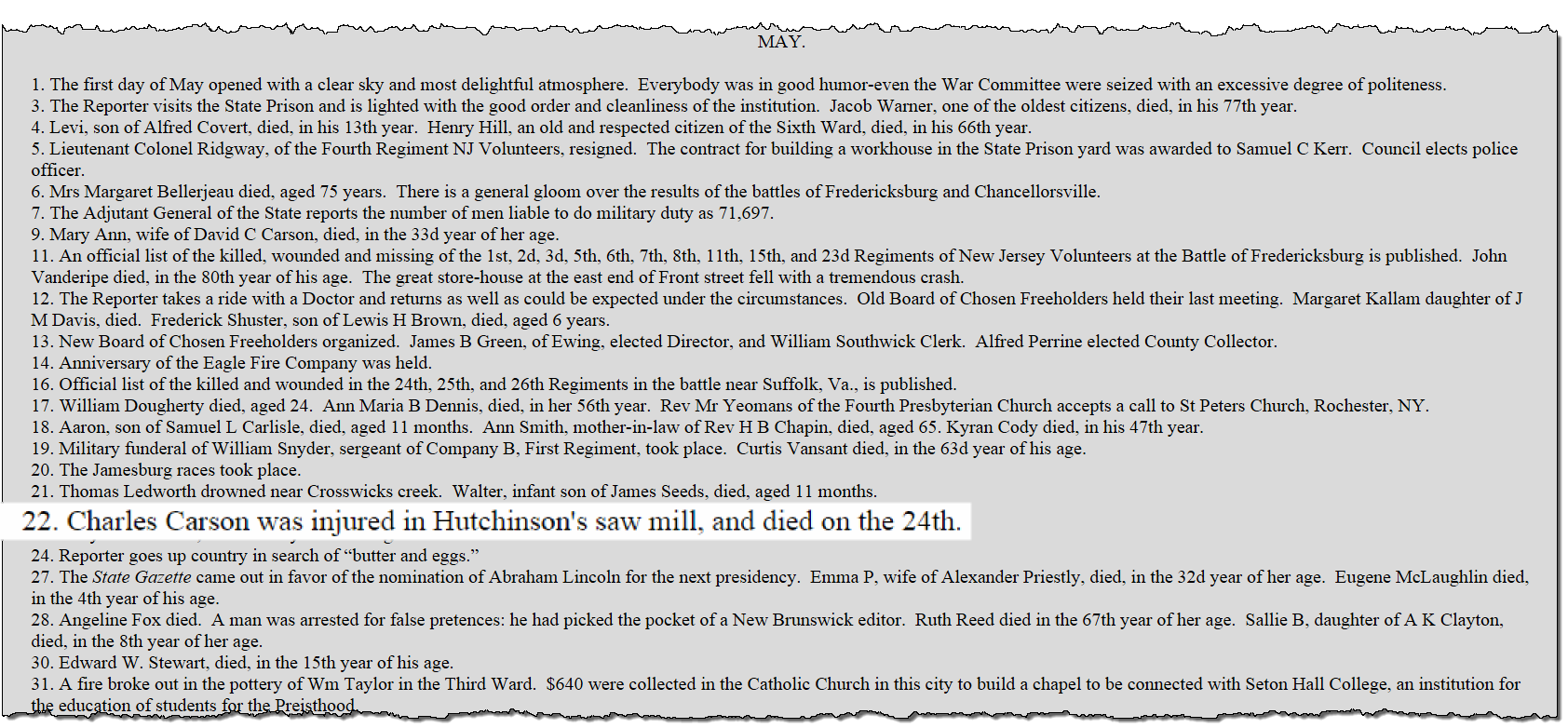
Fast forward a few months to early 2003. The Old Mill Hill Society (OMHS) had a web presence at the time, consisting mostly of transcribed records like city directories and obituary indexes. Included among these records was something called the “Chronological Indexes”, a succinct listing of events in the local newspaper, published on New Year’s Day, which covered events of the prior year. Four Chronological Indexes were then online: 1856, 1857, 1863, and 1870. Like any good genealogist, I worked with what was available and reviewed them all. Imagine my surprise when I read this stark entry for May 1863:

“22. Charles Carson was injured in Hutchinson’s saw mill, and died on the 24th.”4


Charles Carson death in the 1863 chronological index

Could this be the first tangible clue that my Charles Carson died 24 May 1863 as a result of injuries sustained in a sawmill accident two days prior? It certainly fit within the timeline that I had already established. I was cautiously optimistic. I needed to learn more about this man and more about the accident that claimed his life. The fact that the entry was included in an annual roundup of news items meant that it was reported on or near the time of the event.

I made a new research plan with this last record in mind. My plan included locating the following items:

  1. The 1863 death record for Charles Carson in Trenton, New Jersey
  2. Any news articles regarding the accident and subsequent death
  3. A probate file in Mercer County, New Jersey for Charles Carson
  4. Hutchinson’s sawmill to learn if it was near the last known residence of the Carson family

Check back for a future installment to see how well I executed my plan.

Notes and sources:

1 Jean [Owens], “Re: Kansas surnames,” discussion list, 23 Oct 2002, Genealogy.com, GenForum: Kansas Genealogy Forum (http://genforum.genealogy.com/ks/  : accessed 16 Nov 2002), message 12392.

2 Dawn Bingaman, “Re: Kansas surnames Carson – Hopkins,” discussion list, 16 Nov 2002, Genealogy.com, GenForum: Kansas Genealogy Forum (http://genforum.genealogy.com/ks/ : accessed 16 Nov 2002), message 12547.

3 “1880 United States Census Household Record,” database, FamilySearch (https://familysearch.org: accessed 02 May 2003), entry for Caroline Carson, District 1, Chambersburg, Mercer County, New Jersey, citing National Archives microfilm publication T-9, roll 789, sheet 500A.

4 Franklin S. Mills, “Index to the Year 1863.” Daily True American (Trenton, New Jersey), 1 Jan 1864, transcription, Old Mill Hill Society website (http://oldmillhillsociety.org/research/chronoindex/Index1863.htm : accessed 11 Jun 2003). This website was located using the Wayback Machine and can be viewed today at this link:
https://web.archive.org/web/20030310174958/http://oldmillhillsociety.org/research/chronoindex/Index1863.htm.
Sharp-eyed readers will also note there was another Carson entry among the news items. See 9 May 1863: “Mary Ann, wife of David C. Carson, died in the 33d year of her age.”

From Deed to Plat Map, Part 2

Creating a Plat Map from a Metes and Bounds Land Description: A New Jersey Example. Part 2 demonstrates the platting of a parcel using a free online tool

In part one of this two-part post, I created a call list, a stripped down extract of the lines in the 1847 deed that includes the compass points and distance. Armed with this information, I can begin drawing my land plat.

Although I own a copy of Deed Mapper by DirectLine Software, it was installed on my old desktop computer in another room in the home. I vaguely recalled that I had not yet installed the newer version, and didn’t know where the media was to install it on my laptop. So I decided to do an online search for other platting options. That is when I discovered Deed Platter. I am not sure how I overlooked this tool previously – it appears that it was released in 2004.

genealogytools-dot-net-website-deed-platterDeed Platter is a free utility available at the GenealogyTools.net website

Here is a portion of the Hammell to Carson deed with the first two line calls indicated.1847-hammell-to-carson-first-two-calls-indicated

Line call 1 reads: “…South twenty degrees East twenty nine chains and eighty three links…”
Line call 2 reads: “…South fifty four degrees and a half west ten chains and ten links…”

This information is highlighted in my line call worksheet, created in Microsoft Excel.

line-calls-hammell-carson-first-two-highlighted

The highlighted information from my call worksheet is shown in the Deed Platter form. The direction column in my worksheet needs to be broken down into three parts in order to be input into the form: direction, degrees and bearing.

deed-platter-data-entry-form-first-2-line-calls

Deed Platter shows the distance in poles by default. By using the drop down arrow, you can choose from a variety of distance measures, including rods, perches, arpents and Spanish varas. Fill in the bottom portion of the form to have that information included in your map (i.e. grantor, grantee, township, county, state and deed citation information).

This is what the first two calls look like platted using the Deed Platter software.

deed-platter-plat-map-of-first-two-line-calls

This plat map is far from complete but I wanted to demonstrate the process and not just the end result. Continuing working through the line calls, I end up with a Deed Platter table that looks like this:

genealogy-tools-deed-platter-9-calls-in-table

When I finished recording all the line calls from my worksheet into the Deed Platter table, I clicked the Plat Deed button to get a final plat map of the 1847 land purchased by Daniel Carson in East Windsor Twp., Mercer Co., New Jersey.

hammell-to-carson-1847-deed-plat-map

There is an additional table of information that can only be seen once the deed is platted that allows you to include markers and neighbors. I was unable to find a way to get that information to then be displayed on my map, though.

deed-platter-markers-neighbors-table

Markers and neighbors input into the table below the map are not displayed on the map itself. Click on image to enlarge.

Deed Platter is a great, free utility to plat a single parcel of land, but it is not without its shortcomings. Output capabilities appear to be limited to Save or Print, but may depend on which browser is used. With the Google Chrome browser, I was finally able to Print to a PDF file.

The real value in land platting is to place that land parcel somewhere on the globe, and to plat the entire neighborhood (some of whom may be kin), neither of which can be done with this software. I did not see any option to export my plat map for use in another mapping program.

Seeing the land platted definitely helps visualize a complex land description that otherwise just seems like an abstract concept. The Deed Platter software will certainly help you do that.

In summary, successful land platting is comprised of four steps, demonstrated in my two-part post.

1. Acquire a copy of the complete deed whenever possible
2. Transcribe the deed, making a full and complete copy
3. Extract the land description into a separate document that can be marked up
4. Plat the deed using platting software or by hand using paper, pencil and a protractor

If you think you’d rather tackle mapping manually, I can recommend several offline resources: Land & Property Research in the United States by E. Wade Hone (chapter 7) or How to Plot Land Surveys by Neal Otto Hively.

From Deed to Plat Map, Part 1

Creating a Plat Map from a Metes and Bounds Land Description: A New Jersey Example.

Part 1 demonstrates the preparatory work involved prior to the actual drawing of the plat map.

LAND. It was the opportunity to own land that led many of our ancestors to cross the ocean to America and, in some cases, traverse the continent. Since land was of vital importance to our ancestors, it should be equally important to genealogists wanting to form a more complete picture of their ancestors’ lives.

Even with the large numbers of original documents now online, deeds for New Jersey are not yet among them. So, I traveled to the Family History Library in Salt Lake City, Utah last fall where I spent three days reading microfilm and creating digital copies of deeds involving my Carson family and their associates who lived near Trenton, the state capitol of New Jersey.

One of the deeds I examined was an 1847 Sheriff’s Deed of two parcels confiscated by Mercer County Sheriff John Hammell to satisfy a judgment returned by the State Supreme Court of New Jersey against Aaron Eldridge in favor of Daniel Carson. The lands were formerly owned and occupied by Abraham Rogers, deceased.

hammell-to-carson-nj-deed-1847
Portion of a deed between John Hammell, Sheriff of Mercer County, New Jersey to Daniel Carson of East Windsor Township. (Click this or any other image to enlarge.)

I transcribed this deed using my word processing software. Recall that a transcription
is “an exact copy”. [1] To fully analyze a record, we must spend some time with it. For me, the process of converting handwritten records into documents in my word processor facilitates both my understanding of the record and later recall of that record. Transcribing a record also allows me to search my digital files and retrieve the transcribed text for later use in research reports and the like.

hammell-to-carson-deed-transcription
Portion of my transcription of the 1847 deed. I capitalized the names of the parties mentioned within the body of the transcription for easier identification.

The complete metes and bounds description of this land from this deed is as follows:

“…Beginning at a stone standing in the middle of the road leading from Cross Keys to the Assunpink Bridge being a corner to George Newell’s lot thence along the middle of the road according to the bearing of the compass in the year of our Lord eighteen hundred and thirty two South twenty degrees East twenty nine chains and eighty three links to the corner of John H Hutchinsons land thence along his line South fifty four degrees and a half west ten chains and ten links to a stone corner to the Heirs of Amos Rogers deceased thence along their line North forty seven degrees and three quarters West twenty one chains to a stone in a pond thence north seventy three degrees West nine chains and forty one links to a stone thence north thirty six degrees and a half West eight chains and thirteen links to a stone thence north fourteen degrees and a quarter West four chains and forty one links to Augustus Gordons line in the middle of the road leading from Assunpink Bridge to nottingham Square thence along said line and road north seventy three ^ degrees and three quarters East twenty three chains and ninety seven links to the corner of the aforesaid George Newell’s lot thence along his line South twenty degrees East two chains and two links thence north seventy three degrees and three quarters East five chains to the Beginning containing seventy acres be the same more or less…”

The key to working with survey descriptions like the above is to separate out the calls into corners and lines. Patricia Law Hatcher describes one such method in her book entitled “Locating Your Roots: Discover Your Ancestors Using Land Records” (Cincinnati, Ohio: Betterway Books, 2003) : 140-142 that I have successfully used, and will show here today. A line will include both a direction and a distance and a corner is where two survey lines meet, usually delineated by a naturally occurring landmark, such as a stone or a tree. A metes and bounds survey normally will start with a corner and subsequent calls will alternate between lines and corners.

Take the first part of this survey as an example:

Corner
Includes landmark
…Beginning at a stone standing in the middle of the road leading from Cross Keys to the Assunpink Bridge being a corner to George Newell’s lot
Line
Includes direction and distance
thence along the middle of the road according to the bearing of the compass in the year of our Lord eighteen hundred and thirty two South twenty degrees East twenty nine chains and eighty three links

Working through the calls in the deed, and following Hatcher’s method of visually notating the corners and lines with different symbols, my extracted information looks like this in part:

hamell-to-carson-hatcher-example-cropCorners and lines in the survey description have been separated out as an aid in later platting of the land

I marked the corners with the copyright symbol and used an arrow bullet for the lines, but copyright-arrowyou can use anything that helps you to visually separate the information.


The ultimate goal of this exercise is to get a complete description of the land. You don’t want to miss a call and end up with an incorrect plat map. Using Hatcher’s method will minimize the chances of that happening. My deed transcription and later extract of the land description can be further distilled into the essential elements for the actual platting: the boundary line calls.

line-calls-hammell-to-carson-1847
A line call in a survey typically includes both a direction and a distance. A chain is a unit of measurement equal to 66 feet. There are 100 links in a chain. [2]

Now that I have a complete description of the boundaries of the land purchased by Daniel Carson, I can begin to actually map, or plat, the land. I will demonstrate that process in my next post using a freely available online tool.

Sources:

[1] Elizabeth Shown Mills, “Skillbuilding: Transcribing Source Material”, OnBoard 2 (January 1996): 8; Board for Certification of Genealogists (http://bcgcertification.org/skillbuilders/skbld961.html : accessed 16 Jul 2015).

[2] See image of a Gunter’s surveying chain and description at Wikipedia, “Gunter’s chain,” Wikipedia, The Free Encyclopedia, (https://en.wikipedia.org/w/index.php?title=Gunter%27s_chain&oldid=652072667 : accessed 16 Jul 2015).